

The Town's Active Transporation (AT) trail is designed to be a paved, multi-use pathway designed for walking, running, and cycling. It's an important step toward making Antigonish a more walkable and active town.
This project is funded in part by the Government of Canada https://www.infrastructure.gc.ca/.
On This Page
-
Project A: West Street to Highland Drive [Complete]
Project B: St. Ninian Street [Started July 2026]
Project C: Columbus Field [Pending approval]
Project D: East Main Street [Nearly complete]
Steps in our Project
Project A: West Street to Highland Drive
Status: Finished
This phase of the AT Trail was completed in the Fall of 2024. It runs along West Street from roundabout at Old Highway 104 to the intersection at Highland Drive.
Project B: St. Ninian Street
Status: Started July 20, 2026
This phase picks up where Phase A ended at the intersection of Highland Drive, West Street, and St. Ninian Street. It continues down St. Ninian Street to Church Street replacing the sidewalk with one shared-use trail.

Project C: Columbus Field
Status: Pending Approval
This section will create a new footpath, including a pedestrian bridge, and improve accessibility.
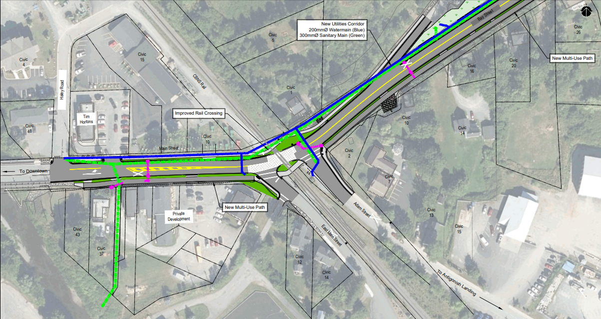
Project D: East Main Street
Status: Started in the Fall 2025, nearing completino
This section of the AT Trail was included in the Town's Bay Street Capital Project; a separate infrastructure upgrade that involves roadwork, drainage improvements, and accessibility enhancements. Since the AT Trail route overlaps with work being done in this area, it made sense to complete both projects together to reduce disruptions and save costs.
This phase of the trail begins just after the bridge at the east end of Main Street and goes up to Adam Street. The sidewalk will be replaced with a shared-use trail. The section of the trail from the bridge to the railway track will be completed in the Spring of 2026.
A new railway crossing that is pedestrian friendly and accessible will be included in the second phase of the Bay Street Capital Project and is pending council approval.
Frequently Asked Questions (FAQs)
How much is this costing the town?*
The total project cost is estimated at $4.92 million, with over 73% of the original estimated project cost funded by the Government of Canada and the Province of Nova Scotia.
- Total estimated project cost: $4.92 million
- Government funding: $2.99 million (73% of the original estimated project cost)
- Town’s projected contribution: $1.93 million (after additional grants)
- Total AT Costs to Date: $1.36 million
- Total Covered by Funding: $1.33 million
- Total Municipal Contribution to Date: $27,837 *last updated March 21, 2025
Will the St. Ninian phase narrow the street?
Yes, but it stays within provincial guidelines.
- Between Martha Drive and Notre Dame, the narrowing is minimal.
- Slight narrowing of 1.8 meters east of Notre Dame.
- 8 meters is the final road width (the same as West Street
Will parking spots be lost on St. Ninian Street?
Yes, the parking spots between Notre Dame Avenue and and Hillcrest Street will be removed. The Town will be doing a parking study in 2026-2027 to identify overall parking trends, needs, and opportunities.
What is the benefit of connecting the AT Trail to the County’s AT network?
A larger, connected trail system allows more people to safely walk and bike around the region. It supports active transportation, local businesses, and sustainable travel options.
Can the money be used for paving and sidewalks instead?
No, the funding is specifically for AT infrastructure. However, AT trails can be considered as upgrading the traditional concrete sidewalks with wider, paved pathways that are accessible.
Why not use concrete?
Concrete isn’t suitable because it wouldn’t provide a smooth and accessible surface for all users.
History of the Active Transportation Trail Project
The vision for a walking and cycling-friendly trail system in Antigonish has been in development for over a decade. Here’s a look at how we got here:
- 2007 – Trail Development Study began
- 2014 – Antigonish Town & County Active Transportation Plan was created
- 2016 – Active Transportation Committee was formed
- 2020 – Town & County completed the Active Transportation Functional Plan and submitted applications for Investing in Canada Infrastructure Program (ICIP) funding
- 2021 – The Town received project approval in June
- 2022 – The County received project approval in July
- 2024 – Project A completed along West Street, to Highland Drive.
- 2025 – Community engagement session and survey. Results of the survey can be found here: pdf What We Heard (11.28 MB)
- 2026 – Project B started in July
Key Benefits of the AT Trail
Our AT Trail offers a wide range of benefits for our community, making Antigonish a healthier, greener, and more connected place to live and visit.
Here’s how the trail enhances our town:
- Promoting Health & Wellness: The trail encourages walking, cycling, and other forms of active movement, helping residents stay fit and healthy. By providing safe and accessible routes, it supports a more active lifestyle for people of all ages.
- Environmental Sustainability: The trail helps cut down on traffic congestion and carbon emissions. This contributes to cleaner air and a healthier environment, supporting our town’s commitment to sustainability and creating a net-zero community.
- Boosting the Local Economy: Our trail is not just for residents—it’s also a draw for visitors. Connecting key areas of town by foot or wheels (non motorized) it will provide easy access to local shops, restaurants, and attractions, helping support local businesses.
- Building Community Connections: The trail provides a welcoming space for residents to come together, socialize, and enjoy outdoor activities. Whether you’re out for a walk or a bike ride, the trail fosters a sense of community and belonging by offering a safe and inclusive space for everyone.
- Improving Safety & Reducing Traffic: With designated paths for cyclists and pedestrians, the trail helps separate non-motorized traffic from cars, making it safer for everyone. It’s an ideal option for families, children, and commuters who want to travel safely across town without worrying about traffic.
- Accessible for All: The trail is designed to be accessible to people of all ages and abilities, ensuring that everyone has a safe and convenient way to reach key destinations. Tactical plates are used on sidewalks at intersections to assist visually impaired users of the path. These texted surfaces provide tactical feedback underfoot, signaling the edge of a sidewalk.
- Creating Beautiful, Recreational Spaces: The trail enhances the natural beauty of our town. It’s a perfect place for outdoor recreation, whether you’re jogging, biking, or simply enjoying being outside.
- Saving on Transportation Costs: The trail provides an affordable and eco-friendly transportation option for residents, reducing the cost of commuting. The goal is to make active transportation an attractive and realistic option for our residents.
Key Facts:
- Planning for this trail began in 2013 and wouldn’t have been possible without the support of the Government of Canada and the Province of Nova Scotia. Over 73% of the original estimated project cost is funded with the support of these two levels of government, totaling $2,990,830.
- Since the original project approval, the Town received a one-time Sustainable Services Growth Fund Grant from the Province of Nova Scotia that was allocated to this project for a total of $414,526.24.
- The route that was chosen is called the AT Spine. It creates the initial link to the County’s AT Corridor that runs along Trunk 4. The spine offers opportunities for future expansion into other major arterial streets and neighborhoods. At this time, the only commitment the Town has is to the construction of the rest of the AT Spine.